this post was submitted on 13 Oct 2023
118 points (100.0% liked)

World News

22170 readers
84 users here now

Breaking news from around the world.

News that is American but has an international facet may also be posted here.


Guidelines for submissions:

These guidelines will be enforced on a know-it-when-I-see-it basis.


For US News, see the US News community.


This community's icon was made by Aaron Schneider, under the CC-BY-NC-SA 4.0 license.

founded 3 years ago
MODERATORS
 

the front page is now like half articles on this currently, so it's probably time for a megathread because none of us want to keep track of 12 threads on this subject and all the resulting comments. only major subsequent developments (for example, boots on the ground; pronunciations by governments; that sort of stuff) will get their own thread. otherwise please post stuff in here for the time being. any threads not meeting this criteria will be locked and removed. thank you in advance for your cooperation.

(page 2) 40 comments
sorted by: hot top controversial new old
[–] bbbhltz@beehaw.org 6 points 1 year ago (1 children)

Maps and Misinformation

Sorry, not news or updates, but also not worth creating a thread.

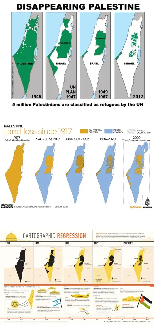
I've been seeing lots of maps on Lemmy (mostly in French-speaking communities communities). A number of them look like this:

standard conflict maps

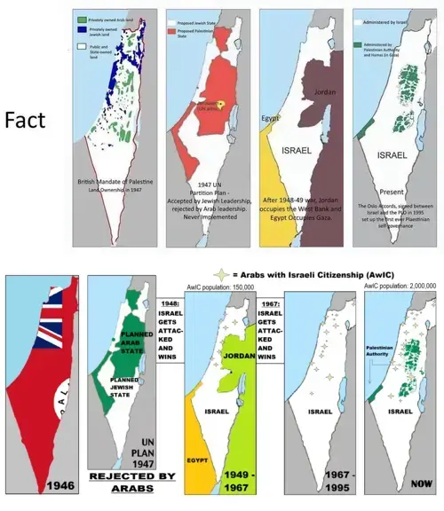
And then I've seen others that look like this (usually labelled as "fact" or "reality"):

alternative versions

With the exception of an amazing 3-day event that took place in my school (we had some history professors/researchers come in over 3 days and present us arguments from both sides, then moderate a debate...) I received no education about this, and even if I had it would have been about 20 years ago or more.

I suspect we have all seen a version of this map before. I can read the Wikipedia, and watch the documentaries, but where should I look to be able to come to a decision on my own regarding these maps? Meaning, is one of them more factual than the other?

[–] jarfil@beehaw.org 5 points 1 year ago* (last edited 1 year ago)

All those maps seem to show the same things, in slightly different ways. Basically, "statistics massaging" done with maps.

The "Fact" one seems to have the most information, as in:

  • Since 1917, the British had control ver the "Mandate of Palestine", which was neither Israel nor Palestine.
  • Both Jews and Arabs started buying land and settling there, hoping to become the majority population in case a referendum was held when the British retired.
  • Since 1941, the Jewish ideated a plan on how to win a possible referendum by getting One Million of their own in there, presenting it in 1944 as a solution for Holocause refugees, but then realizing that it wouldn't be enough, that they'd still be missing people and they'd need "Arab refugees", as in Jews fleeing persecution from Arab countries.
  • In 1947, after WWII, the UN proposed a plan to split the land, which the Arab countries rejected.
  • In 1948 the British planned to GTFO... and just the day before, Israel was formed and declared that the whole land would be theirs.
  • The moment the British left, all the Arab countries attacked Israel which they saw as illegitimate... and with the idea of genociding everyone.
  • However, Israel won that war, and let any Arabs choose whether to stay or GTFO. About 150,000 decided to accept Israeli citizenship, about 700,000 got pushed into Jordan/Palestine.
  • As predicted, a lot of Jews fled Arab countries fearing persecution, which propped up the numbers of Israeli citizens, and further increased the hatred in Arab countries.
  • In 1967, Israel got attacked again, and won again, letting it lay claim to the area previously known as Jordan/Palestine.
  • But people in that area, were mostly Arabs, which didn't sit well with Israel, who started a colonization process, mainly to cut off the "Palestine enclave" from Jordan... and to intersperse some Jewish population inside, lest the area decoded to hold a referendum and the Arab side win.
  • People in the Gaza area were Arab/Palestinian, and it has open access to the sea, so instead Israel tried to contain those people by walling them off, and telling Egypt to take them... which Egypt doesn't really want to (we're in the middle of a worldwide migration crysis, nobody wants millions of immigrants).
  • In 1995, after a lot dirty tactics from bother sides, a Palestinian governance was established... but by then the ex-Jordan area was already decimated by Israeli colonists.

Misinformation:

  • The "disappearing Palestine" map, starts by claiming all the territory was Palestine, which is false, it was a "Mandatory Palestine" under British control. If you compare it with the first "Fact" map, you'll notice it claims all the white area as Arab owned, which is false.
  • The UN plan seems to be correct on all the maps, little to manipulate there since it failed anyway.
  • The 1948/1949 maps match what Israel claimed after preemptively declaring itself as a state, getting attacked, and winning.
  • The 1967 maps also show how Israel got control over the whole area, and progressively has been eating away at any possible Arab/Palestinian claim.
  • The 1995 and "NOW" maps show why Israel conceded a Palestinian governance: mainly over territories where people identifying as Palestinians are no longer a majority.

Personally, I'd say the "Fact" one along the AlJazeera one, paint the most complete picture.

For sources, check Wikipedia for:

[–] Five@slrpnk.net 6 points 1 year ago

Noura Erakat: Western Leaders & Media Are Justifying Israel’s “Genocidal Campaign” Against Palestinians

The unfolding crisis in Gaza, where relentless Israeli bombardment has killed more than 1,500 people since Saturday, is “a humanitarian catastrophe,” says Palestinian American human rights attorney Noura Erakat. She says Western leaders and the mainstream media have relied on racist, Islamophobic tropes to build a false consensus “that war is inevitable and that whatever consequences come out is the fault of Hamas, thereby further blaming the victims for their own killing and massacres.” Erakat also decries the Israeli order that 1.1 million residents in Gaza relocate under threat of a ground invasion. “What we are seeing is a genocidal campaign. You cannot forcibly transfer 1.1 million Palestinians in a 225-square-mile enclosed area. There is nowhere for them to go,” says Erakat, an associate professor at Rutgers University and author of Justice for Some: Law and the Question of Palestine.

[–] Five@slrpnk.net 5 points 1 year ago
[–] sdx@beehaw.org 5 points 1 year ago

The USA are deploying a second CSG to the eastern Mediterranean

I have directed the USS Dwight D. Eisenhower Carrier Strike Group (CSG) to begin moving to the Eastern Mediterranean. As part of our effort to deter hostile actions against Israel or any efforts toward widening this war following Hamas's attack on Israel, the Strike Group includes the guided-missile cruiser USS Philippine Sea (CG 58), guided-missile destroyers USS Gravely (DDG 107) and USS Mason (DDG 87), and Carrier Air Wing 3, with nine aircraft squadrons, and embarked headquarters staffs.

[–] pineapplelover@lemm.ee 4 points 1 year ago

There was a lemmy post that showed beautiful pictures of Israel and Hamas before the attacks and I can't seem to find that post.

[–] ram@bookwormstory.social 3 points 1 year ago* (last edited 1 year ago) (1 children)
[–] Five@slrpnk.net 3 points 1 year ago (1 children)
[–] ram@bookwormstory.social 2 points 1 year ago

Oop fixed ty

[–] Five@slrpnk.net 3 points 1 year ago
[–] iHUNTcriminals@lemm.ee 3 points 1 year ago (2 children)
load more comments (1 replies)
load more comments
view more: ‹ prev next ›