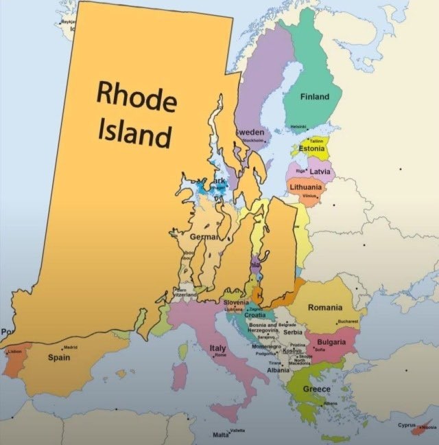
I've never given a moment of thought to the overall shape of Rhode Island. It's always just been so small on every map I've seen that it's an unidentifiable blob with an arrow pointing to it. I feel like I'm seeing it for the first time.
A community for Cartographers with nothing left to lose.
Rules:
Don’t be awful Lemmy Guidelines Still Apply.
We are agents of chaos I’ve created this to be the alternative to the community I used to manage on the website that shalt not be named “mapporncirclejerk”
Live and let die Meme trends happen, so please don’t message mods asking to take down maps that are repetitive to a bit.
Reposts Vs. Covers Not all reposts are evil- if someone posts something that has been done years ago, it serves to bring old memes to the new users. I call these meme covers. However it can be done in excess which makes it a repost and spam. Mods will determine if a post is a cover or a repost.
No impersonating mods I can’t believe I had to make this rule.
No harassing mods on an appeal We can talk it out, and we will be acting in good faith when making decisions. If you disagree with a removal, you are free to message for clarification or to appeal by giving some added context.
Bans Bans will be set to a maximum of 365 days for humans, and a minimum of 365 years for bots. I believe people can change, so if you are banned for good reason, do know that it is not permanent, it is just a way to say “take time to grow and come back when you are ready”.
I've never given a moment of thought to the overall shape of Rhode Island. It's always just been so small on every map I've seen that it's an unidentifiable blob with an arrow pointing to it. I feel like I'm seeing it for the first time.
Me too! Had no idea there were all those islands either.
Needs to be renamed to Rhode Islands.
This image is also missing Block Island, which has RI's sea border with New York state.
The Colossus at Rhodes Island
listen I know this barely has to do with anything but I simply can't not share this random fact

Did you know that this image everyone uses as a clip art for colonialism is called "Rhodes Colossus" and it was originally drawn for an 1892 satirical article about British colonialist Cecil Rhodes who planned to lay down railroad and telegraph lines across Africa, from Cape to Cairo (insanely hard task at the time).
The joke was that colonizers viewed themselves as gods and had a satirical verse about Cecil (who was a major asshole in case you weren't sure). But as often goes satire transcended itself and became the image for colonialism.
Well, how colonialists view themselves (the original intent) and how we now think the ideas behind colonialism makes colonialists look (i.e. their self-image; arguably, its current usage) aren't terribly disparate in form, one could argue.
Mercator projection strikes again
Rhode Island is neither a road nor an island. Discuss.
Is this a shitpost or can you provide a source for this?
Rhode Island can not be contained in any source.
It's slightly smaller than Alaska though.
It's smaller than Alaska but bigger than San Marino.
Shitpost. It's a little bit bigger than Luxembourg, though!
I asked Lumo the following:
Which is bigger, Rhode Island or Ontario Canada?
Ontario is far larger than Rhode Island.
Rhode Island – about 1,034 square miles (≈ 2,678 km²) Ontario, Canada – about 160,000 square miles (≈ 415,600 km²) So Ontario’s land area is roughly 150 times the size of Rhode Island.
Rhode Island is puny. PUNY!
Trusting AI? I'm afraid this source says otherwise.
https://thetruesize.com/#%3Fborders=1%7E%21MTUwNDQzODg.MTA4MTIwMTUMTE5ODk5OTc%28ODM3NzY5Mg%7E%21CONTIGUOUS_USMTAwMjQwNzU.MjUwMjM1MTc%28MTc1%29MQ%7E%21INNTI2NDA1MQ.Nzg2MzQyMQ%29Mg%7E%21CNOTkyMTY5Nw.NzMxNDcwNQ%28MjAw%29Mw%7E%21US-RI*MA.MTgwMDAwMDA%28MjEx%29NA
We're going to have to agree to disagree then.